Places

Discover the places on our routes — history, nature and landmarks.

The catalogue continues to grow. See the linked source for visit details.

Settlements · 5,256

Places found: 5256 · Showing 4,585–4,608 of 5,256 · Page 192 / 219

Map of Bulgaria with a marker for Tsakonitsa (Mezdra Municipality)Representative point of the settlement. Overview map; confirm the exact visiting address.LOCATION · BULGARIATsakonitsa (Mezdra Municipality)NRepresentative point of the settlementMap: Global Tour · Outline: Natural Earth

Representative point of the settlement. Overview map; confirm the exact visiting address.

Bulgaria · Vratsa

Settlements

Tsakonitsa (Mezdra Municipality)

Tsakonitsa is a village in Mezdra Municipality, Vratsa Province, Bulgaria. EKATTE code: 78015. Elevation range: 300–499 m. This profile uses the official National Register of Settlements. View the location on the map and add the settlement to your personal itinerary.

About this place
View location

Map of Bulgaria with a marker for Tsani Ginchevo (Nikola Kozlevo Municipality)Representative point of the settlement. Overview map; confirm the exact visiting address.LOCATION · BULGARIATsani Ginchevo (Nikola KozlevoMunicipality)NRepresentative point of the settlementMap: Global Tour · Outline: Natural Earth

Representative point of the settlement. Overview map; confirm the exact visiting address.

Bulgaria · Shumen

Settlements

Tsani Ginchevo (Nikola Kozlevo Municipality)

Tsani Ginchevo is a village in Nikola Kozlevo Municipality, Shumen Province, Bulgaria. EKATTE code: 78032. Elevation range: 200–299 m. This profile uses the official National Register of Settlements. View the location on the map and add the settlement to your personal itinerary.

About this place
View location

Map of Bulgaria with a marker for Tsaparevo (Strumyani Municipality)Representative point of the settlement. Overview map; confirm the exact visiting address.LOCATION · BULGARIATsaparevo (Strumyani Municipality)NRepresentative point of the settlementMap: Global Tour · Outline: Natural Earth

Representative point of the settlement. Overview map; confirm the exact visiting address.

Bulgaria · Blagoevgrad

Settlements

Tsaparevo (Strumyani Municipality)

Tsaparevo is a village in Strumyani Municipality, Blagoevgrad Province, Bulgaria. EKATTE code: 78046. Elevation range: 700–999 m. This profile uses the official National Register of Settlements. View the location on the map and add the settlement to your personal itinerary.

About this place
View location

Map of Bulgaria with a marker for Tsar Asen (Alfatar Municipality)Representative point of the settlement. Overview map; confirm the exact visiting address.LOCATION · BULGARIATsar Asen (Alfatar Municipality)NRepresentative point of the settlementMap: Global Tour · Outline: Natural Earth

Representative point of the settlement. Overview map; confirm the exact visiting address.

Bulgaria · Silistra

Settlements

Tsar Asen (Alfatar Municipality)

Tsar Asen is a village in Alfatar Municipality, Silistra Province, Bulgaria. EKATTE code: 78063. Elevation range: 100–199 m. This profile uses the official National Register of Settlements. View the location on the map and add the settlement to your personal itinerary.

About this place
View location

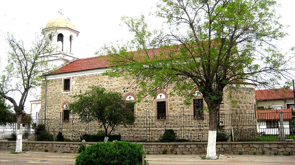
Photograph from Tsar Asen (Pazardzhik Municipality)

Photograph from Tsar Asen (Pazardzhik Municipality)

Bulgaria · Pazardzhik

Settlements

Tsar Asen (Pazardzhik Municipality)

Tsar Asen is a village in Pazardzhik Municipality, Pazardzhik Province, Bulgaria. EKATTE code: 78056. Elevation range: 300–499 m. This profile uses the official National Register of Settlements. View the location on the map and add the settlement to your personal itinerary.

About this place

Photo: The original uploader was Kiu4i4ovata at Bulgarian Wikipedia . · CC BY-SA 3.0 · License

View location

Map of Bulgaria with a marker for Tsar Asen (Popovo Municipality)Representative point of the settlement. Overview map; confirm the exact visiting address.LOCATION · BULGARIATsar Asen (Popovo Municipality)NRepresentative point of the settlementMap: Global Tour · Outline: Natural Earth

Representative point of the settlement. Overview map; confirm the exact visiting address.

Bulgaria · Targovishte

Settlements

Tsar Asen (Popovo Municipality)

Tsar Asen is a village in Popovo Municipality, Targovishte Province, Bulgaria. EKATTE code: 78077. Elevation range: 300–499 m. This profile uses the official National Register of Settlements. View the location on the map and add the settlement to your personal itinerary.

About this place
View location

Map of Bulgaria with a marker for Tsar Kaloyan (Tsar Kaloyan Municipality)Representative point of the settlement. Overview map; confirm the exact visiting address.LOCATION · BULGARIATsar Kaloyan (Tsar Kaloyan Municipality)NRepresentative point of the settlementMap: Global Tour · Outline: Natural Earth

Representative point of the settlement. Overview map; confirm the exact visiting address.

Bulgaria · Razgrad

Settlements

Tsar Kaloyan (Tsar Kaloyan Municipality)

Tsar Kaloyan is a city in Tsar Kaloyan Municipality, Razgrad Province, Bulgaria. EKATTE code: 77308. Elevation range: 200–299 m. Municipal centre. This profile uses the official National Register of Settlements. View the location on the map and add the settlement to your personal itinerary.

About this place
View location

Map of Bulgaria with a marker for Tsar Samuil (Tutrakan Municipality)Representative point of the settlement. Overview map; confirm the exact visiting address.LOCATION · BULGARIATsar Samuil (Tutrakan Municipality)NRepresentative point of the settlementMap: Global Tour · Outline: Natural Earth

Representative point of the settlement. Overview map; confirm the exact visiting address.

Bulgaria · Silistra

Settlements

Tsar Samuil (Tutrakan Municipality)

Tsar Samuil is a village in Tutrakan Municipality, Silistra Province, Bulgaria. EKATTE code: 78238. Elevation range: 0–49 m. This profile uses the official National Register of Settlements. View the location on the map and add the settlement to your personal itinerary.

About this place
View location

Map of Bulgaria with a marker for Tsar Shishmanovo (Makresh Municipality)Representative point of the settlement. Overview map; confirm the exact visiting address.LOCATION · BULGARIATsar Shishmanovo (Makresh Municipality)NRepresentative point of the settlementMap: Global Tour · Outline: Natural Earth

Representative point of the settlement. Overview map; confirm the exact visiting address.

Bulgaria · Vidin

Settlements

Tsar Shishmanovo (Makresh Municipality)

Tsar Shishmanovo is a village in Makresh Municipality, Vidin Province, Bulgaria. EKATTE code: 83363. Elevation range: 200–299 m. This profile uses the official National Register of Settlements. View the location on the map and add the settlement to your personal itinerary.

About this place
View location

Map of Bulgaria with a marker for Tsar Simeonovo (Vidin Municipality)Representative point of the settlement. Overview map; confirm the exact visiting address.LOCATION · BULGARIATsar Simeonovo (Vidin Municipality)NRepresentative point of the settlementMap: Global Tour · Outline: Natural Earth

Representative point of the settlement. Overview map; confirm the exact visiting address.

Bulgaria · Vidin

Settlements

Tsar Simeonovo (Vidin Municipality)

Tsar Simeonovo is a village in Vidin Municipality, Vidin Province, Bulgaria. EKATTE code: 66442. Elevation range: 0–49 m. This profile uses the official National Register of Settlements. View the location on the map and add the settlement to your personal itinerary.

About this place
View location

Map of Bulgaria with a marker for Tsar-Petrovo (Kula Municipality)Representative point of the settlement. Overview map; confirm the exact visiting address.LOCATION · BULGARIATsar-Petrovo (Kula Municipality)NRepresentative point of the settlementMap: Global Tour · Outline: Natural Earth

Representative point of the settlement. Overview map; confirm the exact visiting address.

Bulgaria · Vidin

Settlements

Tsar-Petrovo (Kula Municipality)

Tsar-Petrovo is a village in Kula Municipality, Vidin Province, Bulgaria. EKATTE code: 78224. Elevation range: 200–299 m. This profile uses the official National Register of Settlements. View the location on the map and add the settlement to your personal itinerary.

About this place
View location

Map of Bulgaria with a marker for Tsaratsovo (Maritsa Municipality)Representative point of the settlement. Overview map; confirm the exact visiting address.LOCATION · BULGARIATsaratsovo (Maritsa Municipality)NRepresentative point of the settlementMap: Global Tour · Outline: Natural Earth

Representative point of the settlement. Overview map; confirm the exact visiting address.

Bulgaria · Plovdiv

Settlements

Tsaratsovo (Maritsa Municipality)

Tsaratsovo is a village in Maritsa Municipality, Plovdiv Province, Bulgaria. EKATTE code: 78080. Elevation range: 100–199 m. This profile uses the official National Register of Settlements. View the location on the map and add the settlement to your personal itinerary.

About this place
View location

Map of Bulgaria with a marker for Tsarev dol (Tutrakan Municipality)Representative point of the settlement. Overview map; confirm the exact visiting address.LOCATION · BULGARIATsarev dol (Tutrakan Municipality)NRepresentative point of the settlementMap: Global Tour · Outline: Natural Earth

Representative point of the settlement. Overview map; confirm the exact visiting address.

Bulgaria · Silistra

Settlements

Tsarev dol (Tutrakan Municipality)

Tsarev dol is a village in Tutrakan Municipality, Silistra Province, Bulgaria. EKATTE code: 78118. Elevation range: 100–199 m. This profile uses the official National Register of Settlements. View the location on the map and add the settlement to your personal itinerary.

About this place
View location

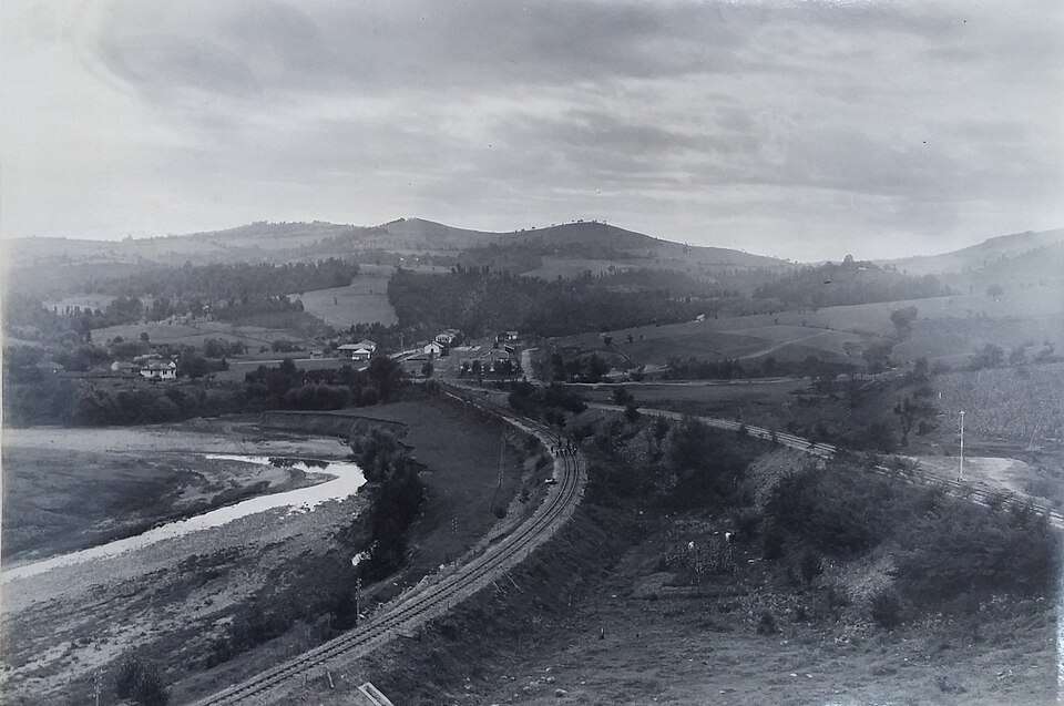
Historical photograph of Tsareva livada (Dryanovo Municipality)

Historical photograph of Tsareva livada (Dryanovo Municipality)

Bulgaria · Gabrovo

Settlements

Tsareva livada (Dryanovo Municipality)

Tsareva livada is a village in Dryanovo Municipality, Gabrovo Province, Bulgaria. EKATTE code: 12677. Elevation range: 300–499 m. This profile uses the official National Register of Settlements. View the location on the map and add the settlement to your personal itinerary.

About this place

Photo: Unknown author Unknown author · Public domain · License

View location
Map of Bulgaria with a marker for Tsareva polyana (Stambolovo Municipality)Representative point of the settlement. Overview map; confirm the exact visiting address.LOCATION · BULGARIATsareva polyana (Stambolovo Municipality)NRepresentative point of the settlementMap: Global Tour · Outline: Natural Earth

Representative point of the settlement. Overview map; confirm the exact visiting address.

Bulgaria · Haskovo

Settlements

Tsareva polyana (Stambolovo Municipality)

Tsareva polyana is a village in Stambolovo Municipality, Haskovo Province, Bulgaria. EKATTE code: 78094. Elevation range: 200–299 m. This profile uses the official National Register of Settlements. View the location on the map and add the settlement to your personal itinerary.

About this place
View location

Map of Bulgaria with a marker for Tsarevets (Dobrich-selska Municipality)Representative point of the settlement. Overview map; confirm the exact visiting address.LOCATION · BULGARIATsarevets (Dobrich-selska Municipality)NRepresentative point of the settlementMap: Global Tour · Outline: Natural Earth

Representative point of the settlement. Overview map; confirm the exact visiting address.

Bulgaria · Dobrich

Settlements

Tsarevets (Dobrich-selska Municipality)

Tsarevets is a village in Dobrich-selska Municipality, Dobrich Province, Bulgaria. EKATTE code: 78152. Elevation range: 200–299 m. This profile uses the official National Register of Settlements. View the location on the map and add the settlement to your personal itinerary.

About this place
View location

Map of Bulgaria with a marker for Tsarevets (Kardzhali Municipality)Representative point of the settlement. Overview map; confirm the exact visiting address.LOCATION · BULGARIATsarevets (Kardzhali Municipality)NRepresentative point of the settlementMap: Global Tour · Outline: Natural Earth

Representative point of the settlement. Overview map; confirm the exact visiting address.

Bulgaria · Kardzhali

Settlements

Tsarevets (Kardzhali Municipality)

Tsarevets is a village in Kardzhali Municipality, Kardzhali Province, Bulgaria. EKATTE code: 78149. Elevation range: 300–499 m. This profile uses the official National Register of Settlements. View the location on the map and add the settlement to your personal itinerary.

About this place
View location

Map of Bulgaria with a marker for Tsarevets (Mezdra Municipality)Representative point of the settlement. Overview map; confirm the exact visiting address.LOCATION · BULGARIATsarevets (Mezdra Municipality)NRepresentative point of the settlementMap: Global Tour · Outline: Natural Earth

Representative point of the settlement. Overview map; confirm the exact visiting address.

Bulgaria · Vratsa

Settlements

Tsarevets (Mezdra Municipality)

Tsarevets is a village in Mezdra Municipality, Vratsa Province, Bulgaria. EKATTE code: 78135. Elevation range: 200–299 m. This profile uses the official National Register of Settlements. View the location on the map and add the settlement to your personal itinerary.

About this place
View location

© 2026 Global Tour